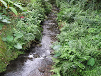
I drove over the bridge in Waipahu yesterday and had a chance to glance ma uka out my passengerʻs side window and look down into Waikele stream.
Waikele means "muddy waters" and the water in the stream was very dark and muddy indeed after all the recent heavy rains. Sides of the steep stream beds were also eroding away and I saw an intact section of concrete steps, a section of chain link fence and some other things that had fallen down to the lower banks of the stream with the erosion. I wish I was able to stop and get a picture.
Waikele stream cuts through the center of Waipahu Cultural Park and enters into Pearl Harborʻs West Lock on the west side of Waipio Peninsula. Directly opposite on the east side of Waipio Peninsula was once a large fish pond called "Loko Eo". This fish pond is now coved by Ted Makalena golf course. Just south of this area on Waipio Peninsula is the large Waipio Soccer Complex that has been put here in more recent years. The soccer complex (288 acres) covers what was once another large fish pond called "Loko Hanaloa" which was 195 acres in size before it was filled in.
Waikele is the former name of Waipahu (Waipahu is in the ahupuaʻa of Waikele). The area between West Lock and Loko Eo was terraced throughout, continuing for more than a mile up into Waikele Stream. The lower terraces were fed with water from a famous spring at "Waipahu" which means"exploding water" (Native Planters of Old Hawaii, pp. 470 - 472). Waipahu was the name of the spring that was located near where the former Oʻahu Sugar Mill stands in Waipahu town.
Take a moment and pause to remember what was once in this area beneath your feet next time you travel through the old sugar plantation town of Waipahu or play golf or soccer on Waipio Peninsula.
Saturday, December 13, 2008
Konahuanui


"Beautiful is (Mt) Konahuanui towering above Nuʻuanu Valley, a gourd holding dew, the mountain often has a mantle of cloud" (Native Planters of Old Hawaii" pp. 222).
So it did at the very peak of the mountain when I took the top picture a couple of days ago from Maunawili Valley. A couple hours later though, the peak had cleared (bottom picture).
Mount Konahuanui is the upper most elevation of nā ahupua'a of Kailua & Nuʻuanu. It is the highest peak in the Koʻolau mountains and the second highest peak on Oahu after Mount Kaʻala in the Waiʻanae mountains.
There is a famous legend about a moʻo that lived in a pool on Konahuanui peak. A hairless dog had been killed and was being taken to the kona side of the island through the Nuʻuanu Pali as a tribute to the aliʻi nui and to be eaten.
At the foot of the Pali in the hala groves of Kekele, the moʻo of Konahuanui called out Pehea lā, ke kaʻahele nei ʻoe? ("So, you are travelling?"). The killed and dismembered dog in the ʻumeke (calabash) called out ʻAe (yes). The carriers were so terrified that they dropped the calabash and fled. The hairless dog emerged alive from the laulau in the calabash and trotted up Mt. Konahuanui to meet the moʻo.
Consequently, no hairless dogs were ever eaten again (Native Planters of Old Hawaii" pp. 247-248).
Monday, December 1, 2008
Ahupuaʻa o Kahaluʻu


Kahaluʻu stream is fed by Ahuimanu, Waiola & Kalohaka streams further inland. Due to the topography of Kahaluʻu, the loʻi of this ahupuaʻa were not continuous, but were tucked away in pockets that were fed by these streams. Wet land and dry land type taro were grown in this area.
The seaward low elevation flat lands of the ahupuaʻa of Kahaluʻu and the two adjacent ahupuaʻa of Waiheʻe & Kaʻalaea to the northeast made up one of the largest wet land taro growing areas along the Koʻolau (windward) coast of Oahu (Native Planters of Old Hawaiʻi - p. 454).
Ahuimanu stream is shown in the top picture. I took this picture about 100 yards upstream (ma uka) from where Ahuimanu steam is joined by Waiola stream.
The other two pictures show a nice stand of ʻOhe (bamboo) which was growing on an embankment above the stream. ʻOhe in traditional Hawaiʻi was used for many things including being made into musical pipes, rattles, fire blowing tubes, water containers & stamps for marking tapa.
The water of this stream on this day was crystal clear and the plants growing on the edges of the stream were indeed uluwehiwehi loa.
Subscribe to:
Comments (Atom)


